Winter 2026-27 Forecast: What a Very Strong El Niño Means
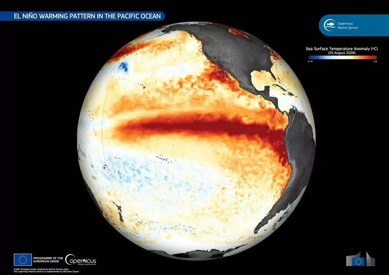
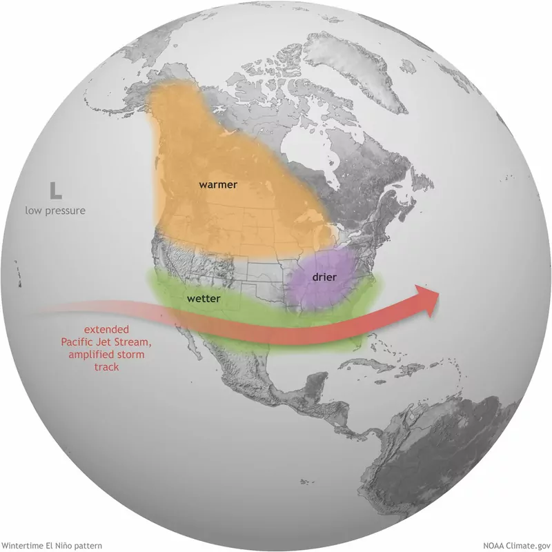
This winter is shaping up around a very strong El Niño. NOAA's Climate Prediction Center (CPC) says El Niño is strengthening, with a greater than 90% chance of a very strong event this fall and winter, and a 75% chance of a historic one in October to December, stronger than any El Niño on record back to 1950 (CPC, September 10). In the US, an El Niño winter usually means a wetter southern tier, a warmer north and an active storm track. The effects are likely, not guaranteed.
What NOAA's outlook says, region by region
This is the CPC's winter picture, from its September 17 outlook discussion. The outlooks cover temperature and precipitation only; they do not forecast snowfall.
| Region | Winter (late fall to early spring) |
|---|---|
| Northern tier (Montana to Minnesota, northern Plains) | Warmer than normal favored, with the highest chances (50 to 60%) along much of the northern tier and the interior Northwest |
| Pacific Northwest | Interior Northwest: warmer and slightly drier. Coast: warmth tempered by cooler water offshore |
| California | Wetter than normal favored, up to 50 to 60% near the coast from December to April. The CPC says the odds may be raised in its next outlook |
| Southwest and Four Corners | Wetter than normal favored. Slight tilt to warm that fades to equal chances |
| Southern Plains and Gulf Coast | Wetter than normal favored: up to 40 to 50% in the southern Plains, and 70 to 80% over southern Georgia and northern Florida |
| Southeast | Wetter. Temperatures near normal from November to April, because the El Niño cool signal competes with a warm long-term trend |
| Mid-Atlantic and Northeast | The wet signal extends up the Atlantic coast into New England. Warm tilt in the fall |
| Great Lakes | A modest tilt toward drier than normal |
| Alaska | Warmer than normal favored for the central and eastern mainland and Southeast Alaska (50 to 60% in Southeast Alaska) |
"Favored" means the odds lean that way. They are not a prediction that every place will be warm or wet.
Rain or snow?
Wetter and warmer together is a recipe for rain where you'd expect snow. Storms along a southern track can bring heavy snow to the Ohio Valley, Mid-Atlantic and Northeast when cold air is in place, but a mild winter pushes snow lines higher. Higher mountains in the West tend to do better than low-elevation resorts. That is a general pattern, not a CPC snowfall forecast, and no two El Niño winters play out the same.
Why this one is different
- It's very strong. Sea surface temperatures in the eastern equatorial Pacific have topped +3.0°C above average. The Niño-3.4 index was +1.8°C in the CPC's September update, and the weekly value had reached +2.0°C by September 17.
- The Pacific pattern is unusual. The three biggest El Niños since 1950 (1982-83, 1997-98 and 2015-16) all came when a long-term Pacific pattern called the PDO was in its positive phase. This time it is negative, which the CPC says may dampen the usual impacts in some areas.
- Cold snaps can still happen. The CPC notes cold outbreaks in the northwest quarter of the Lower 48 are possible, but unlikely to change the 90-day average much.
- It should fade in spring. The CPC expects El Niño to weaken significantly by March to May 2027, possibly becoming neutral later in spring.
What it means outside the US
The World Meteorological Organization (WMO) says a strong El Niño is expected to dominate global climate patterns through the fall of 2026 and raises the odds of above-normal temperatures across much of the world. Typical effects it lists (WMO):
- More rain and flooding: parts of South America, East Africa and the southern United States. In East Africa El Niño is linked to a wetter "short rains" season from October to December.
- Drought risk: eastern and northern Australia, Indonesia, southern Africa and parts of South Asia, because of a weaker monsoon.
- Fewer Atlantic hurricanes.
- A warmer world next year. El Niño's warming effect on global temperature is usually strongest in the year after it develops, which is why 2024 was the hottest year on record after the 2023-24 El Niño. That points to 2027.
Some news stories call this a "super El Niño". The WMO does not use that term.
What comes next
- October 8: the CPC's next monthly El Niño update, with any change to the odds.
- Mid-October: the CPC issues its official 90-day outlooks once a month near mid-month, at 8:30 a.m. Eastern. The CPC said the next set, due mid to late October, may strengthen the wet signal in California. Check its December to February outlook maps.
- Then monthly, with updated winter outlooks in November and December.
This page will be updated when NOAA's new outlooks come out. For the dates the clocks change before the shorter days, see when do the clocks go back.
Quick answers
Will winter 2026-27 be cold or warm?
NOAA favors warmer than normal across the northern US and Alaska, near normal in much of the Southeast, and wetter than normal across the southern US. Local cold snaps can still happen.
Will there be more snow this winter?
NOAA does not forecast snowfall. Wetter and warmer conditions can mean more rain in places that usually get snow, and heavy snow where cold air meets a storm. High mountains in the West and Southwest have the best chance of a good snow season.
What is El Niño?
The warm phase of a natural climate pattern in the tropical Pacific, in which surface water in the central and eastern Pacific is much warmer than normal. It shifts rainfall and winds around the world, and typically returns every two to seven years.
Is this the strongest El Niño ever?
It might be. The CPC gives a 75% chance that October to December will be a historic event, exceeding every El Niño since 1950.
Does El Niño mean a mild winter everywhere?
No. It tilts the odds. The wettest signal is across the south, the warmest across the north, and the Southeast and Great Lakes see weaker signals.